This is a true copy of a forum debate about SBC where the Police were shot by the Kelly gang in 1878. These following 25 pages were lost when one of the participants complained to forum host ProBoards.com. Despite numerous efforts to have the whole forum re-instated by me, this topic was one of several threads on DEE's 'Ned Kelly Truth forum' that questioned the many mythologized elements of the Kelly story, and is the reason for much personal attack on those that may have alternative views of how Kelly history is recorded. Bill Denheld May 2014


The Great Debate about Stringy-Bark Creek   PAGE 2


bill Member
*

bill Avatar


Post by bill on Feb 20, 2014 at 11:30am

Thank you Sarah, Dee and Horrie
I will answer Sarah first.

Hello Sarah,
Perhaps we are getting all too technical.
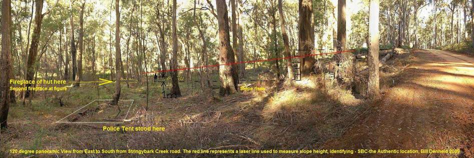
The issue is to explain why the two huts site is the place where the police camped and were shot.

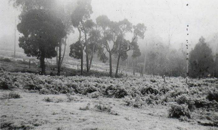
The water course starts near the top of the range on what was the Engelke farm land and this gentle undulating land forms a gully.
On this farm is the head of the SBC gully, so you can see it is a pretty un remarkable gully heading down hill.
As it heads down the hill the gully still does not hold water as a creek.
Picture of the head of SBC.

www.ironicon.com.au/images/engelke-topend-stringybark-ck.jpg

http://www.ironicon.com.au/images/engelke-topend-stringybark-ck.jpg

Here is a picture of the farm to the right of the above scene 
www.ironicon.com.au/images/engelke-dairy-stringybark-ck.jpg

When it rains the water quickly soaks down into the sandy gravel soils but does not run off on top of the ground, rather this rain water permeates down to a hard rock bottom some 300 metres below. But as the downhill slopes as per the Geology cross section map shown on page 1, eventually the ground surface meets up with the hard granite rock bottom where some what lowerdown the water oozes out - we call a spring just UP from where the two huts are. From there this water flows freely down the gully gutter we now know as SBC and it keeps flowing and flowing all year round because of the massive sponged water storage up above.

You are right the spring is higher up than where the police camped. But because just to the south of the camp there is a steep slope that levels to a flatter area on top- this has been described as the little hill in The Herald newspaper only 12 days after the shootings. You can read about this in my document www.ironicon.com.au/stringybark_ck_the_authentic_location.pdf  
( print out page 36 and 37)

The map page 36 shows contours only on the west bank but the creek has cut through this country for millinia forming very steep sides leading up from the two huts to where the spring actually is located. From the police camp you cannot see the spring, or from the spring you can not see the police camp because of the little hill in between. But from the top of the little hill you probably could be able to see both. Please read part of the Herald report transcript on page 37 and relate the red numbers to the map.

The point being, Dan was sent back to the spring area because from the police camp you could not look past the little hill - the slope in the back ground of the Burman photo.

In 1985 I was able to walk in to see the spring, maybe fifty to eighty metres, there is a pool water hole that had been damed up but was breached. Further up the gully it was dry. Due to the bush fires in 2005, the whole area is overgrown with some sort of scrub and the area is now almost impossible to pass. I gave it a go a few years ago and could not get further than 8 metres.
Bill


Last Edit: Feb 20, 2014 at 11:35am by bill: Repeat chaned back -miss read.


Dee
Administrator
*****

Dee Avatar


Post by Dee on Feb 20, 2014 at 12:29pm

Thanks Bill I enjoyed reading that! You've been doing this for so long!
So you’re saying that the spring is NOT a long way from the two huts site as suggested by Sarah? And do you agree it makes sense as Horrie says, that there must have been changes to the exact contours and layout of the land given what's been taking place ever since?


Glenn
Guest

Guest Avatar

Post by Guest on Feb 20, 2014 at 1:44pm

Hello Dee,

What Bill is referring to is possibly what was a damned off section of the creek done by earlier occupants of the area. Now ruined. He discovered this when he ventured up the creek back in 2003 or 2005

This does not constitute a spring. There is no spring at or near the two fireplace site.

This was discussed and agreed upon previously on the SBC forum.

Hence Bill’s offer to me to join him in locating the source of the spring. This was January last year.


Nothing has changed since then.

Cheers,

Glenn


bill Member
*

bill Avatar


Post by bill on Feb 20, 2014 at 7:19pm

Regarding Horrie and Dee's question,

Dee, As we can see it is difficult to get exact meanings as Sarah has pointed out.

Quote Horrie-
To expect everything today to be identical with the Burman photographs of 1878 is a bit rich.
Quote Dee - And do you agree it makes sense as Horrie says, that there must have been changes to the exact contours and layout of the land given whats been taking place ever since?

Having spoken to Charlie Engelke in 2003 (now deceased), he lived at the top of SBC road. He, as a youngster walked up and down SBC road, he said that while most of the land east of the SBC road were 'rung' ring barked it was never cultivated, and the "dry trees still standing shot out saplings, and all the bush has grown up in the last 50 years, ( now 60). We can take from that, the creek, the bush, and contours are untouched.

Apart from 'new roads' ( maps 1884 courtesy Sheila Hutchinson's book Heritage and History on My Doorstep'), at the time were not formed in any way except fence lines defining properties and road reserves, public tracks along these reserves up and down dale, numerous low spots (Charlie said in his time) were impassable bogs during the winter months. But at the time of the police camp there was no such roads only 'bridle tracks', - no maps. However what the CSI team refer to being their 'Spring' would later become one of those bogs where natural water run off formed a little soggy bit of ground - this was just down a little dip south of the Kelly tree not far- today it runs under the road today from west to east through a six inch pipe. But if this was the likely spring referred to by CSI, there would be little need for Dan Kelly to go there in case the police came back from that direction, because if the Kelly tree site was where the police had camped, Dan would not have needed to have gone 'down' to this hollow 'spring', rather Dan would have just needed to get a view across that low spot to see if the police came from that direction. If this is not proof enough the CSI@SBC spring is nonsense, I'd be happy to be a monkey's uncle.

Horrie, to answer your question, the little corner where the two huts is situated is virtually unchanged.
On the other side of the creek opposite, East of two huts, the east bank was dug up for gold for about fifty metres or so. However this does not constitute any change in contours except for a number of digger holes and mounds.

Up the creek apart from a small dammed section nothing would be changed and yes, a lot of timber may have been got out in the 1930's but only if fairly easily accessible. I can show you the tracks they left behind. Remember most of the land became free hold by 1884 /5 but timber cutters did not access the area till 45 years later when McCashneys built the sawmill over Kelly camp in 1929. It was said to be in virgin bush according to Charlie Engelke whose father was the engine driver for the mill. However one tree was not so luck was the original Kelly tree- the one everyone knew had bullet lead in it from the shoot out was cut down by Harpers sawmill of Benalla as I remember in 1908.

The SBC road went straight past the two huts fireplaces which are about 26 metres in from the road. This road in order reach the top of the ' little hill' most of that part of the road is fill. This means we cannot now not stand on the original ground where the police tent was pitched - on below where the road is today. But non of this has changed the contours relevant to the Burman photos topography.

I will show one view of the two huts site that has never been shown before. It is a panoramic view of approx 120 degrees.

Bill

 
http://www.ironicon.com.au/images/twohutssouthslopefromroad.jpg  

www.ironicon.com.au/images/twohutssouthslopefromroad.jpg
Click link to see full size.


Glenn
Guest

Guest Avatar

Post by Guest on Feb 20, 2014 at 8:21pm

Smoke and mirrors again. Bill.

Still trying to disguise the fact that there is no spring at the two fireplace site.

If the creek and contours are untouched. Why did you find the need to alter the creek alignment on your scaled layout? Not enough distance for the tent perhaps?
70yards from the creek places it to the other side of SBC road. Interesting how things move around to suit your particular scenario.


Dee
Administrator
*****

Dee Avatar


Post by Dee on Feb 20, 2014 at 9:26pm

I can see you guys are never going to agree! But I am sure you’re both genuine in your desire to find the precise spot, but its clearly not obvious. and we haven’t even started on the third site!

For me - getting back to Bills point about knowing exactly where a thing happened -  Stringy Bark Creek is exactly where it happened. For most of us I think it would be enough just to be in that area and walk about in all that bush ,up and down the gullies and the creeks, the springs bogs and spear grass, all of which was the domain of the Gang and of the Police at the time, all of it has been a witness to the Kellys, the police, the murders, the search parties, everyone who came after to satisfy their curiosity, to pay homage to the Police , hunt for souvenirs, to re-imagine what happened, commune with nature or the bush, or even the dead...all these things happened in that broader space, not just in one small corner of it. Just to be there would be enough for me.

How come nobody wants to talk about anything else?

Last Edit: Feb 20, 2014 at 9:27pm by Dee


Horrie
Guest

Guest Avatar

Post by Guest on Feb 20, 2014 at 11:43pm

I did not suggest "the lie of the land" generally had changed. But it is obvious that the logs featured in the Burman photos are long gone, so too is the apparently flat ground in the Burman photos (and the hut post). If this is the spot, and I believe it is, things have obviously changed over 136 years. Not the general topography - but the smaller details.

I don't know if Burman's original camera exists, but none of the experts have ever discussed the various perspective distortions caused by cameras then and now. Maybe focal length, depth of field, etc., etc., could explain some of the visual anomalies.

If the site was identical today, as it was in 1878, there would be no argument would there?


Glenn
Guest

Guest Avatar


Post by Guest on Feb 21, 2014 at 10:21am

Dee,

I understand what you are saying. The whole area is important and should be respected. To some the exact locating of events doesn’t matter to others it does.

In brief
Up until 1992 the site was recognised as being near the Kelly tree. It was around that time that Ian Jones announced that in his opinion it was not correct.
As he has such a high profile few would question him. So the site was moved. Thousands of people now go and stand in the wrong location trying to imagine it all.
Through extensive research and new information that has surfaced in recent years we now know that Ian’s site is wrong.
That is something Bill and I can agree on.

Of course just to say it should be at the Kelly tree area would not be enough. So the CSI@SBC team have gone to extensive lengths to test the information provided.

This was done on both sites, Bill’s and ours. The land was professionally surveyed, distances measured in feet and yards. Etc.
It was not by pure co incidence that the Kelly tree location was chosen.

On the surface Bill’s site can be very convincing. Unfortunately, unless the information is manipulated it does not match.

The spring being one example.

Regards,
Glenn


Glenn
Guest

Guest Avatar


Post by Guest on Feb 21, 2014 at 10:23am

Hello Horrie,

Much of the land remains the same although some areas have been done over. The flat land as in the Burman images remains mostly as it was.
Sadly the spring area on the other side of the road near the Kelly tree was bulldozed as a fire break when the fires went through in 2005. All the trees were flattened. Gradually the swamp gums etc are making a recovery.
As is the spring. Behind this location the surrounding hills form something like a little valley, the ground in this area is hard, the water collected makes it’s way down under the surface to form the spring. Much as it does with there creeks in the area.
From there it makes it way both under and over the road down towards the creek. ( I know nothing of a 6” pipe under the road though. This may have been put there in the last 4 months)

Re Camera.

A good point. This has been previously extensively discussed on other forums. I agree it would be difficult if not impossible to take anything like the Burman images with a modern camera.
This could be discussed again but will open up another can of worms and take us off on another tangent. It may encourage Bill to whip out his viewer scope again. Quite honestly I am over that thing.

Regards,
Glenn


bill  Member
*

bill Avatar


Post by bill on Feb 21, 2014 at 10:25am

Hello Horrie,

In my document just in case you did not see or understand my home made apparatus, the Viewer Scope.

If you or any of the readers were to come to SBC with me and looked through the Viewer Scope with the features of the Burman photo etched onto the clear glass, a sliding peep hole to look through can be changed for any focal length in or out.

You wrote quote-
"If the site was identical today, as it was in 1878, there would be no argument would there?"

I can set the scope up for you to look through, except for the trees, you will see the landscape shape matches the etched image exactly.

Horrie, you will find no other place anywhere along SBC that matches the Burman photo except for at the two huts still today.
For those that have seen this demonstrated there is no argument.
Bill


bill Member
*

bill Avatar


Post by bill on Feb 21, 2014 at 10:33am

I reply to the Post by Glenn Standing -last post by Glenn on page 1,

Quote- by Glenn
" When you present images like those "Then and Now" pictures above. How about doing them to scale. The figures and the logs are disproportionate to the image. E.G. The log on which the man sits is approx. 24ft long. Show 24ft on the ground.
Show someone actually standing in Kennedy’s position. Otherwise they are meaningless and totally misleading to some.
I think you will find that your camera position will need to be moved much further back therefore the slope height diminishes.

You know full well there is a slope just south of the Kelly tree. Higher in fact than the one you have demonstrated. To say there is not is simply not true. Again misleading.

You have said: "If some one can show me I am wrong I would gladly concede I am wrong.”
Can I really believe that?

Again I ask.
With regards to the StringyBark Creek Forum, saying you just had to give up, Mmmm.

Bill, you can still access and post on that Forum but choose not to. I suspect that because there is many an unanswered question I put to you in relation to the Two Huts, the shingle hut and the one a few Yrds behind which the police tent was pitched.
Your conclusions and the huts just don’t add up. Either your conclusions are wrong or your critique of the CSI@SBC report is wrong or both. Questions which up until now have done your best to avoid.
These question are an integral part of the story and need o be addressed.
Perhaps this should be continued on this forum for all to see. Yes? "


Readers please notice how Glenn and his CSI team don't put anything up them selves.

Glenn says my images 'Then and Now' are not to scale !

Glenn, Why don't you put up your 'Then and Now' images whether they are in scale in scale or not !

Glenn, You say there is a slope just south of the Kelly tree 'Higher in fact than the one you (me) have demonstrated.

Glenn, for us readers your slope need not be higher than in the Burman photo, JUST show us a picture as per the Burman photo so we can all see that Burman could have taken his photos there. ( at or near the Kelly tree)

But Glenn, make sure your image is divided into 3 three parts, a bottom third for the flat ground portion on which the logs sit /lay, then the slope up one third, and what is left is trees and sky. One third for each portion.
PLEASE show us your photo Then and Now.

Glenn, you can ask me all the questions you like, but until you provide any the evidence for the Kelly tree site, it is no use nit picking about ' a few yards this way or that, or behind which hut a tent was pitched, or what is a spring etc, etc, it is all irrelevant nonsense.

Glenn and his CSI team have relied mostly on written text by McIntyre from his Memoirs that Mc himself states was not completed till 1902, or 24 years after the event. In his memoirs Mc will have re read all his notes and tried to re write some to make them as coherent as possible, but we cannot really be sure if when he wrote 70 yards he did not mean 70 feet, when 20 yards we read were steps, by either a long or short legged person. We would doubt if MC did go back with a tape measure in hand. There are typo errors -there are estimates and most is just guess work.

Glenn asks questions for which there are no answers.

If McIntyre said they pitched their tent behind an old hut, we could then assume that hut must have had a front.
We do not know if there was the remains of a third hut that stood besides, on or near the Bridle track ( now the road way) so we will never know all those details. There were a party of three prospectors occupying the spot when one Walter Lynch burnt down Percy Broomfields 'new hut'. We know of 2 ruined huts fireplaces and one had been burnt down as reported in the local paper 15 months before the shootings and the court witness was Sergeant Kennedy! Was the tent pitched behind the remains of this hut?

In his memoirs Mc said the entrance of the tent faced East to the creek. In the Herald account the 'special reporter' said the tent faced North. The special Herald reporter is thought to be non other than G Wilson Hall *, the prop of the Mansfield Gaurdian who six months later wrote the Book The Outlaws of the Wombat Ranges.( *no proof but the Herald wrote 'report' from our special reporter representative who has intimate knowledge )

Glenn, you and your team have provided nothing to substantiate your CSI case for the Kelly tree scenario.

You have some allies over on another bad attitudes forum presenting absolute lies about me- where one Poorflower is throwing up rubbish to do with leaning trees, which last year I have answered conclusively see link- www.ironicon.com.au/newforum/csiatsbcthereport1.htm  
Readers please, for the fun of it see their pathetic simpleton view of nature. Science does not come into their heads.

These Poor flower people publicaly challenges me to provide further answers to their silly questions as if I am a member of that hate forum. Let me tell the readers, some little time back I did try to join up so I could at least defend myself but was and remain rejected by them…. Had I tried to register as a pseudonym they would have welcomed me, but I refuse to be a pseudo that they all are. My attempt to registration was around the same time Dee was struck off their list.

Glenn, we know you and Kelvyn Gill have fallen for Linton Briggs's half baked Kelly tree scenario.
I remember well the day we all listened intently to Linton showing us where the tent had stood - 20 feet west of the road and we all looked around for where the logs in the Burman photo would have been laying. Where was that slope?
www.denheldid.com/twohuts/images/glennbilllintonlisten.jpg

continued next post

Last Edit: Feb 21, 2014 at 10:44am by bill


bill Member
*

bill Avatar


Post by bill on Feb 21, 2014 at 10:37am

Linton said he had believed in this spot for 40 years, he was absolutely convinced and we all went about checking the place out. I decided to do the slope test as in the Burman photo with a long string line and spirit level protractor, For the highest angle I could get was a mear 4 degrees- if looking south west. See map page 11 view 3A.
www.ironicon.com.au/stringybark_ck_the_authentic_location.pdf

When I pointed out this could not be the spot as there was no slope, Linton was speechless me telling him that.
I had thrown him off ? The next day we continued on site and I showed him the Burman photo again. To that Linton said he had re considered everything and decided to turn his scenario around by 90 degrees!
I thought, wow, so much for a forty year old belief ! His next best scenario is shown as 3B on map page11.

After turning his orientation around by 90 degrees, forgetting all the shadow detail on the Burman photo which shows90 % coming from behind the photographers left shoulder, we now have to have the sun high in the sky to the south. gurrrr.
I stepped back and thought, I'm dealing with some very unscientific people here and I took this photo-


pixmaker.com.au/twohuts/images/northviewnearkellytreesite.jpg

You can clearly see there is no slope to be seen. - except maybe, just maybe way across the creek some 200 metres east through the trees on the east bank of SBC. What a joke.

Glenn, I can barely believe a man of your intelligence can keep coming back without putting up anything that re-enforces your case. You need to go by only primary source material that fits on the ground evidence and you will pin point the spot.

Again we can see the aim now of the CSI team is to create doubt in the readers mind that I am wrong, - and in the process they diminish their own credibility.

For all readers if you have not been here before please read the CSI@SBC teams report
www.ironicon.com.au/csi@sbc_bills_comments.pdf
Please remember all the blue text is mine to alert the team of their weird wacky CSI report.

Bill

Last Edit: Feb 21, 2014 at 10:39am by bill


Glenn
Guest

Guest Avatar


Post by Guest on Feb 21, 2014 at 1:24pm

So many questions in one go.

Bill. When you run away from another forum when things don’t go in your favour and laugh it off tells me many things. You were not kicked off but chose to go away.

Yes. The SBC forum may be a closed members only shop. But you can still post. I have asked you politely to answer the questions I put to you on that forum. On several occasions.
Then that is done dusted and finished.

Until such time you get what you get.

You now bring your thoughts across to another forum and start all over again. You have bagged myself and the CSI@SBC team from the outset. Insulted me on more than one occasion.
Wrote things on your web site which I/we could not respond to.

So I do thank you for giving me credit for some intelligence. But it is kind of back handed when you say Kelvyn and myself have fallen for Linton’s half baked Kelly tree scenario.
Yes. When you first showed me your site it was very convincing. As things progressed and tested it unfortunately for you it did not fit. Nor match.
5 members started out on the Investigating team. 4 came out. One yourself against. I’m sorry to have disappointed you.


The team never intended to slam our findings down peoples throats. Copies of the report were sent to DSE and the like for their consideration. If people want a copy of the report they can buy one. Not ideal but that’s the way it goes.
The cost covers the printing charges and the proceeds go to the Glenrowan improvement society. The CSI@SBC team make no money nor want money from the report.
Your comments on the report? Questionable.

I have presented a huge amount of information previously on other forums – Stringybark Creek Forum / Kellycountry2000 forum.

The information in regards to the spring and descriptions near the Kelly tree should really be enough for now.

As there is no spring at the two huts site.


Horrie
Guest

Guest Avatar

Post by Guest on Feb 21, 2014 at 1:51pm

There should be a little private chatroom here for Glenn and Bill to sort out their differences.

Then they can post what they agree on here.


Dee
Administrator
*****

Dee Avatar


 Post by Dee on Feb 21, 2014 at 1:58pm

Bill I am going to read the CSI Report that you provided though I realise that the final one might not be exactly the same and therefore the CSI people will feel I am wasting my time. In the end I have a feeling I am not going to pick sides. I feel I already know where it all happened anyway.

But what I want to say right now is that you all seem to have an amazing passion for that place and an intense interest and knowledge about all the goings on down there. It seems a pity that you agree so much about almost everything but are so bitterly divided. Its not a war. Respect each others passion opinions and knowledge and agree to disagree. :)

The photos that you have posted Bill are quite wonderful - I look at that lovely bush and its hard to imagine that such a peaceful and beautiful environment could be the place where such an appalling series of violent murders took place. I think the most ghastly scene would have been the hunting down of Kennedy, finally to stand over him collapsed in the bush, pleading to be spared and then that final shot at point blank range echoing through the bush and then silence returns....I am sure you all think about this sort of thing in quiet moments when you are there...


bill  Member
*

bill Avatar


Post by bill on Feb 21, 2014 at 6:57pm

Thanks Horrie, Dee and Glenn,

Horrie,
Thank you, a nice thought to get Glenn and I together for a chat.
I've had many chats with Glenn, he's been to our house and we agreed about a whole lot of things over maps - layouts to get a scale on the two huts site in accord with the Burman photos. 

Glenn, I am one for fair discussion and would never have expected the vindictive nasty onslaught that I have had to endure. Iam simply presenting the facts. 

It's a great credit to DEE to form this N K TRUTH forum, as I believe there is so much miss truth out there, it takes a lot of courage to stand up to these bullies. Perhaps it is a reflection of how intimidating the whole Kelly saga was on the population in those days. There is a Kelly mafia out there for all to see.

Dee, regarding the right site at SBC, you and other readers may say 'Oh, why does it matter' ? Well, I think its a disgrace that the authorities allowed a very false place to be sign posted when all along I told them it was wrong by all the evidence, but I was not included in the SBC discussion group. The CSI @sbc report - for what I show is 90% of their final and if I show the rest it is even more ridiculous than the issue I show which is bad enough. 

If we all continue to tell lies, what do we learn from history?

Lets agree to dis agree, I am not running away from any forum Glenn alludes to, it started out as an open forum and as time went on they began to close sections to the public when they knew they were losing the argument.  I know I am right, but is not a good debate because Glenn and his CSI team are not producing the evidence for their selected site at the Kelly tree. 
Bill


PS, Dee, I was going to put up a picture, but why aren't my pictures shown in above postings where I wanted them to be shown. Have you changed the settings? Now there are only image links?

Last Edit: Feb 21, 2014 at 7:58pm by bill


Dee
Administrator
*****


Post by Dee on Feb 21, 2014 at 9:04pm
Hi Bill
Thanks for drawing this problem to my attention. I had been impressed by the way you were making your posts. I would like everyone to be able to post nice big pictures like you did.
I have just spent a couple of hours trying to work it out, searching all the Help Forums for this Forum Board , and haven’t really come up with anything. I have tried posting a picture of my own and using the “Add Attachment” button at top right the best I seem to be able to do is get a Thumbnail size picture which, if you click on it will open up to the full sized Pic. Another Member said they couldn’t Log In a few days ago and I don’t know what the problem was there either. I get the feeling this Forum Boards template we use is a bit “buggy” but I am not literate enough in Computer things to be able to take it any further.

Keep trying - it may sort itself out again sometime.


Last Edit: Feb 21, 2014 at 9:18pm by Dee


sarah
Junior Member
**


Post by sarah on Feb 21, 2014 at 10:14pm

Dee, I would like to point out more bias by you in your description of events in the Kelly story.

“I look at that lovely bush and its hard to imagine that such a peaceful and beautiful environment could be the place where such an appalling series of violent murders took place.”

There were no ‘murders’ at Stringybark Creek and although there was violence and death that happened, it was not ‘violent murder’ as you so disparagingly describe!

Do you really know what happened there and have you read McIntyre’s accounts of how Ned tried to get them to ‘bail up’ (surrender)?

I am now totally disillusioned with this forum and your supposed impartiality.


Glenn
Guest


Post by Guest on Feb 21, 2014 at 10:37pm

Dee,

What is the date on the CSI@SBC copy of the report that Bill provided ? If you would like a current copy I would be pleased to personally deliver one to you. Do you live anywhere near Croydon?


Bill, you have said that : The CSI @sbc report - for what I show is 90% of their final and if I show the rest it is even more ridiculous than the issue I show which is bad enough.

Is that not being vindictive yourself?

Their are 97 pages in the current report. Yet you say you show 90% of it.

Furthermore why would I persist in asking you to return to a forum - if I were loosing the argument?

Yet you also say that if we continue to tell lies, what do we learn from history.

I am also for a fair discussion and an honest one.

So keep it straight and I will be more helpful.

What shall we agree to disagree on to start with?


Dee
Administrator
*****


Post by Dee on Feb 21, 2014 at 11:48pm

Glenn thats a kind offer - do you mean Croydon in Sydney? I have downloaded the copy that Bill provided but have been too busy to study it so far. If you want something to agree to disagree on, am I right in thinking you disagree about the orientation of the Burman Photos, based on where you think the light is coming from?

Sarah, if you look up legal definitions of murder I think you will find it is accurate to describe those deaths as murders. I will open a new thread so this one can be left to discuss the


More to come in due course
Page 1, 2, 3, 4, 5, 6, 7, 8, 9, 10, 11, 12, 13, 14, 15, 16, 17, 18, 19, 20, 21, 22, 23, 24, 25