This is a copy of KC2000 forum SBC News and Views page 5
 

Author Topic
poorflour
Average Member


14 Posts

Posted - 24/07/2010 :  15:29:46  Show Profile  Reply with Quote
During the school holidays we went to Stringybark Creek with our science teacher.

Using the Burman photograph as seen in this newspaper article


We all went to where these photograph's were taken, from the Kellyhaunts site, its over grown now, this spot is just up from the new carpark.


At this spot there is simply nowhere looking around 360 degrees that matches the 2 burman photographs.

 
Go to Top of Page
bill denheld
Advanced Member


Australia
116 Posts

Posted - 24/07/2010 :  17:20:29  Show Profile  Email Poster  Visit bill denheld's Homepage  Edit Reply  Reply with Quote  Delete Reply

Hello poorflour, and all
It is amazing that some supposed Kelly researchers cannot see the area through the Burman photos.
As you seem to have taken a keen interest, I hope you enjoyed your trip to SBC and may I ask, has this been a school project?
Your posting is appreciated. Bill


_____________________________________________________________________


Mr Pseudo and Glenn, you both seem to want to denigrate and find holes in my document - without success.

All this stuff about angles West of North, a stump here, a fireplace there not lining up with a photo edges, a Penny found, oh, dear
who gives a 'proverbial' if an angle is not quite right or something a little out of scale, this is a lot of nit picking !
The important thing is 'are we on the right track', if not why not?

Gentlemen, I note your site would have to have a slope from which you could "overlook" the police tent, as at the two huts site and my scale map.

A hill (slope) as described (by the special reporter ) that would hide the gangs approach from the creek to the south east ( where Ian Jones's Log is located), And note the hill slope has a patch of spear grasses growing near the top that is about 20 feet in diameter.

All this as described fits the site of the two fireplaces, and is the site photographed by Burman.

Mr McIntyre,
As you seem to object to my scenario, please tell the forum readers
where along SBC YOUR site is located, after all you were there.

Bill
Joe.D
Advanced Member


Australia
726 Posts

Posted - 24/07/2010 :  17:34:51  Show Profile  Email Poster  Visit Joe.D's Homepage  Reply with Quote
Hi poorflour,

RE: Your latest post....

The two photos in question is that of where approximately I believe the police tent was pitched back in 1878.

The two photgraphes NO way referes to a 360 degree view of the Burman photo. See the caption under the photos it reads......Could the above site be where the police pitched their tent on October, 26th at Stringybark Creek?

I randomly took several photos in different positions for the purpose of my reference NOT to indicate a 360 degree view of the Burmam photos. The photo was taken looking south standing in the middle of the road.

P.S.....The larger of the two photos you uploaded with your post is that of a dumpscreen....... from google earth

Whoops..... should have mentioned the area where I pitched the tent was bulldozed to make a firebreak during the fires a few years ago. What you now see is re-growth (Weed)and obviously the landscape has been altered....

Hope I have cleared up the confusion ;-)

Joe.D
www.kellyhaunts.org

Edited by - Joe.D on 24/07/2010 18:04:34

Go to Top of Page
Joe.D
Advanced Member


Australia
726 Posts

Posted - 24/07/2010 :  17:49:19  Show Profile  Email Poster  Visit Joe.D's Homepage  Reply with Quote
Hi Bill,

C'mon Bill PLEASE......enough of these silly games......of course we see the area through the Burman photo......we see it very well, too well in fact......obviously you DO NOT!!!!

Joe.D

 
Go to Top of Page
Thomas McIntyre
Average Member


18 Posts

Posted - 24/07/2010 :  20:34:39  Show Profile  Email Poster  Reply with Quote
Mr Denheld,
As I have some idle time at present I now utilise it to continue with my “blah”.
I trust that such “blah” however is read by those with an interest in the location of our camp site in the Wombat.

But before again turning to your recent correspondence, let me digress: I see that “Poorflour” (Oh dear, a nom de plume not in favour with you) has also re-entered the discussion with an observation of photos placed within Mr Dipisa’s material – to which I see that he has made a reply.
But I do wish to make just one comment:
The ground along the western side of the road suffered immeasurable damage when in preparing for the possibility of the out-of-control bushfires a few years back a significant tract of land on the western side of the road both to the North and South of the public amenity was razed by bulldozing – not only the land but the majority of the well established trees and scrub was also destroyed in this operation.
I did in fact observe this work in progress whilst passing through the country en-route to Mansfield.
Poorflour, keep up the interest as I am pleased that your class’s interest is stimulated by your teacher (I have a profound respect for the profession of which I was a member during my time before joining the Victoria Police).

Now Mr Denheld,
I am not one to be baited by your taunts.
I have matters yet to place in the public forum for rational people to consider. (Just as it should be the case for the determining of a site being given full, complete and extensive evidence of ALL matters which would be appropriate to consider in arriving at a verdict.)
And so I return to your words in your last response.

First: “We still have parts of the Bridle track that can be seen along the western bank heading to the two huts site but the road works has covered the track”
So this is the “possible Bridle track” you show in the diagram? Why “possible” if as you assert it can be seen?
Secondly: “a fact Scanlan’s body was found not far from the track”.
Yes, it certainly was but let me repeat my words of how and where his body was located.
When I had found the position of the tent I could have gone to the bodies blindfold. Starting from the tent I took a turn to the left between the stump and the log as shown in the accompanying engraving and then proceeding in the direction of the creek, outside the clearing where they had been searching. I showed them the body of Lonigan. All doubts about the truth of my story were removed by this confirmation of it. Then walking down the creek a little distance close to the bridle track I pointed to the body of Scanlon.

Perhaps Mr Denheld you would be kind enough to mark on your recent diagram the place where the bodies of my two colleagues lay?

Oh, and there is still a little more to go on with.

Third: “you weren't there when that happened”
Well, no that is true, BUT I was there for the recovery of my colleagues mortal remains.
AND as it is clear in the Burman photographs, and in the artistic pictorial representation of the place the ONLY indication of anything burnt are the two posts remaining. No indicative burnt ground, other than the immediate area of the fire at the junction of the log’s can be ascertained in the photographs.

And finally, You now, by marking with a yellow line, propose that a “slope as in Burman photo with spear grasses” is to be seen in the sketch of the camp area in the Australasian Sketcher.
I would respectfully suggest the alleged yellow line slope is of far less an incline than you have indicated in the Burman photographs and of which you make much about.
And why now is the slope in the position you indicate when using the same sketch in your “An interim report to supplement the paper tabled at the Glenrowan Siege Dinner 26 June 2009”, You say:
“This centre fold sketch has been drawn from the Burman photo as primary view. The steep slope as in image 3 above would be between the two central trees - indicating the artist drew it from information provided to him. “

Ah, so the artist drew from information supplied and not from first-hand knowledge!!

Finally, to Mr Standing of whom I have much admiration for his considered evaluations and to which you seem to take such exception to, I just say I look forward to any further material that you choose to share with us.

I do remain yours truly
Thomas McIntyre 2384


I had finished, but then this merits a response:
"who gives a 'proverbial' Well, I do Mr Denheld, such pitiful language does you no credit.

"you both seem to want to denigrate and find holes in my document" It also occurs to me that you give this a run for your money in respect to addressing "Linton Briggs and some members of the team" (quote is from page 7 of your document.)I conclude with an observation I hope does not upset that team, and that is:
that they, as far as I can discern, have not touted their work in the press as you have been prone to do.
Public opinion but most importantly those within the government areas who will determine the outcome, is not to be influenced by such press ramblings but by a considered and tested assessment of ALL material that can be assembled.
I recall your press article in one of the Melbourne paper's made it to around page 30 or so, not an auspicious placement for such I think.)


Sheila Hutchinson
Advanced Member


Australia
66 Posts

Posted - 25/07/2010 :  13:17:06  Show Profile  Email Poster  Visit Sheila Hutchinson's Homepage  Reply with Quote
'The other photograph of the Police Camp site'

Hi Debaters,

I would like to know your views on the photograph that appeared in the Beautiful Mansfield Booklet in May 1897 titled Police Camp Wombat Ranges - Scene of Kelly Outrages. To me this photograph appears to have been taken not far south of the Kelly Tree with the background in a north-easterly direction.

Having had a number of people from Mansfield helping in the search for Sgt Kennedy they would have had no doubt about the location of the spot where the troopers were confronted by the Kelly party even if it was nearly 20 years after the event.

Mr Mac as you were aware of the Glenmore hut sketch I’m sure you would be aware of this photograph.

Bye for now

Sheila
 
Go to Top of Page
Thomas McIntyre
Average Member


19 Posts

Posted - 25/07/2010 :  23:37:36  Show Profile  Email Poster  Reply with Quote
Sheila, Thank you, and a warm welcome to you.
Yes, I have been able to view that photograph from the booklet you mention.
It is an interesting one as it has been snapped when the surrounding country had been opened up for farming and stock running. It certainly provides an interesting view and yes it was certainly taken looking towards the north east as you say. And as to the whereabouts you are also very perceptive as to the locale being nearby to the tree known today as the Kelly tree (of which though this tree is the third to bear this distinction).
The photograph is referred to as of the Police Camp, Wombat Ranges. Scene of Kelly outrage.
And a keen eye will fail to see any remains of a fireplace or two.
You do know that photos do not lie.
The booklet to which you refer – Beautiful Mansfield, was prepared by the Mansfield & District Progress Association, and it has within it many interesting photographs but only the one we talk about is of the Stringybark Creek locality.
Our excellent State library has a copy of this booklet within their archives and it can be, as I am told, seen by reference to it as RARELT 994.5 V66 (my associate has also provided this computer address to allow interested persons to view the photograph - http://www.slv.vic.gov.au/vicpamphlets/1/2/9/doc/vp1296-021-h000.shtml)
Thank you for your question.
And let me say, I have read your very informative book titled Heritage and History on my Doorstep.
I commend it to all to obtain a copy of it for their own enjoyment.
Thos.
 
Go to Top of Page
robert mcgarrigle
Advanced Member


Australia
90 Posts

Posted - 26/07/2010 :  10:22:07  Show Profile  Email Poster  Reply with Quote
 

Edited by - robert mcgarrigle on 26/07/2010 16:19:02


May I ask this simple question. Why wasn't all this evidence produced before sending people off to the incorrect site as is the case now? Are the DSE going to apologise for jumping the gun without knowing all the facts and taking one mans word as being gospel. Everyone in this great SBC debate seems to agree that the police camp site was on the west bank and not the east. Thomas as you seem to have a good grasp of the situation can you at least confirm that the current site is plainly wrong and the correct site is on the west bank. I along with everyone else on the forum anxiously await your answer. I would also like to point out that Bill has the same photo that Mr McIntyre has told us about on page 24 of his document. On page 9 of Bills document he also marks one of the fireplaces and to the naked eye it is very difficult to see. Having viewed the fireplaces myself it is not easy either to see where the other one stands, although it is only about 10 metres from the other. In regards to this photo Mr McIntyre, I don't fully agree with you in regards to a fireplace not being there. What is the small black rise to the left of the lefthand tree? This could be the site but the sharp slope from the flat piece of ground in the Burman photos is not in this photo. (my opinion only). Either the Burman photo tells fibs, is distorted or the photo with the 3 gentlemen is also not the site .I would also like to thank Sheila and Fay for all their work if I haven't done so previously.


Edited by - robert mcgarrigle on 26/07/2010 16:19:02


Sheila Hutchinson
Advanced Member


Australia
67 Posts

Posted - 26/07/2010 :  12:01:41  Show Profile  Email Poster  Visit Sheila Hutchinson's Homepage  Reply with Quote
Re my Heritage and History book:
Mr Mac, thank you for your kind comments; I’ve heard of others perusing it with interest at the SLV
With all of your knowledge of the goings on in the Wombat Ranges it would appear that you have lodgings at this establishment !!

Your timely reappearance on the Forum has sparked interesting dialogue

Sheila
 
Go to Top of Page
poorflour
Average Member


15 Posts

Posted - 26/07/2010 :  18:15:52  Show Profile  Reply with Quote
Please Bill or Joe.D can you or anybody show us a real photograph that can be taken today from the little pitched tent or where the 2 huts fire places are and looks the same ground as the wider Burman photograph we have attached.


Please indicate on your photograph with little pink squares on your photograph where we marked on the Burman photograph, that show the same spot on your photograph.

As we cannot find a spot at these proposed sites to stand, and rotate 360', that we can see where the attached photgraph was taken.

Thank you
Poorflour


Edited by - poorflour on 26/07/2010 18:19:51

Go to Top of Page
Joe.D
Advanced Member


Australia
728 Posts

Posted - 26/07/2010 :  19:56:37  Show Profile  Email Poster  Visit Joe.D's Homepage  Reply with Quote
Hello poorflour........hope you are well.

Considering your interest for the location of the police camp site. I have decided to invite you & your science teacher(and class mates)for an excursion to SBC. There may even be a surprise guest appearance!!

Poorflour, could you be so kind to email me via the kellycountry2000 email system. Otherwise I'll take it upon myself to make contact with your science teacher......

Looking forward to your email....

Joe.D
Go to Top of Page
Thomas McIntyre
Senior Member


20 Posts

Posted - 29/07/2010 :  01:08:43  Show Profile  Email Poster  Reply with Quote
Hello Robert, thank you for your considered recent correspondence.
I make a response for your consideration.
Your question and statement about the current place for the position of our camp is not one I will make any comment about. You need to direct your question to the authority or others with a direct knowledge of the reasons why. I do believe that somewhere in the mists of time Mr Denheld has made his views known.

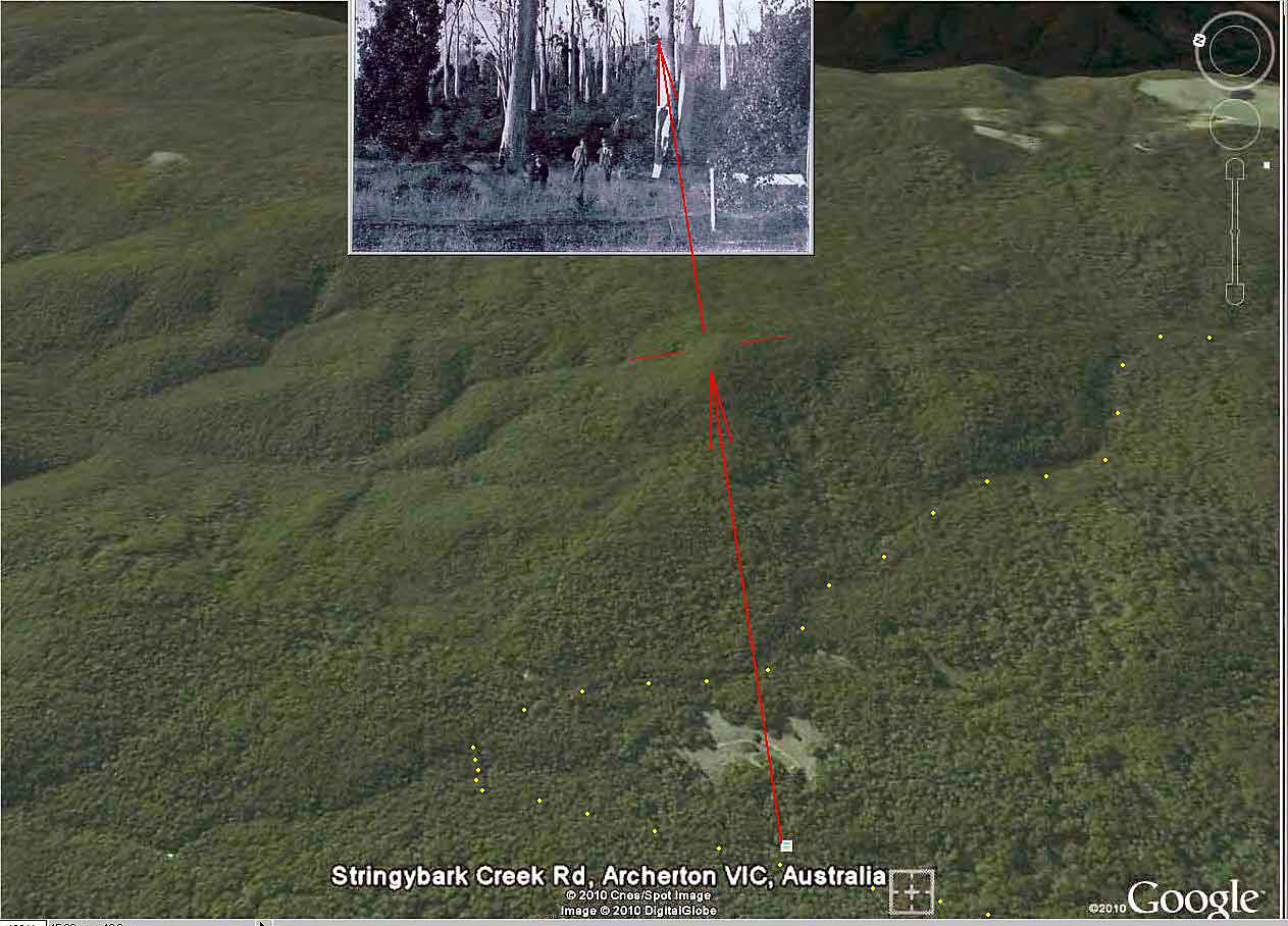
Oh yes, Robert, the camp was on the western side of the creek.

The Beautiful Mansfield booklet’s photograph is in Mr Denheld’s document, and to ensure there is no ambiguity Mr Denheld states that: “this scene was taken across what is now the picnic ground looking east. The scrubby growth behind the men hides the creek. The ridge line in the back ground are the ranges more than 2 km away to the east and can be identified on the topographical map of the area.”
Well, I am unable to see any reason advanced by him as to why he says the photograph was taken where he implies it to be so. Why could not the photograph be from any position along the country from, say the picnic ground going south for some considerable distance?
I have been advised by my asociate that the most ‘accurate’ map available today is Vicmaps’ 1:25,000 map series available from them (and perhaps available in any specialist map selling shop) with contour lines at 10 metre height changes.
This map base was used by Heritage Victoria for their diagram 2205 in the public paper detailing the heritage listing for the Stringybark Creek area. I am also advised this paper has a link to it in an earlier forum topic (around about September 2009).

But what is important is that a ridge is of course the apex of rising ground which ascends from a low point, such as a creek line or shallow valley, and that between the creek and that ridge in the photograph there can well be smaller rises and falls than cannot be seen in this photograph - unable to be discerned because the immediate background is so heavily timbered and covered in scrub.

(By way of explanation, I prefer to use the descriptive term ‘rising ground’ and not slope so as not to confuse my observations with dialogue where the term slope has been and is used).

As to your question – “What is the small black rise to the left of the lefthand tree?” I assume you refer to the Mansfield booklet photograph. Well, Robert I have no idea. The photograph does not provide sufficient clarity to be able to identify with any precision what it is.

So I make a general observation: Much care needs to be exercised when attempting to attribute an absolute label (such as fireplace, post, rabbit, grass clump and so on) to a blurred, ‘dark blob’ or whatever. Just as much care needs to be exercised to ensure optical illusion or a mirage of the mind does not lead to a false conclusion (such as slope).
Assume nothing, prove everything perhaps is a guiding pathway to the truth. Beware the use of digital magnification but use optical enhancement if you wish to see if the indistinct can be made more e distinc or the optical illusion is removed.

There is no sharp slope in the right hand side of the Burman photograph as Mr Denheld claims (on page 9 of his document.
Optical enhancement of this photograph will show clearly that there is however in the background one continuous width of rising ground traversing the photograph.

The slope of which much is made seems to have become an idée fixe.

I am sure those areas of authority which have received Mr Denheld’s paper, and the ‘other team’s’ paper, will take care to analyse the photographs in much detail and not rely on the claims put forward (else they too face the prospect of again getting it wrong, so I respectfully suggest there is yet a fair degree of time to elapse before a resolution can be expected - if indeed there is one).

I do hope your personal interest in this matter remains for as long as it takes.
Thos.
 
Go to Top of Page
robert mcgarrigle
Advanced Member


Australia
91 Posts

Posted - 29/07/2010 :  10:04:04  Show Profile  Email Poster  Reply with Quote
Thank you for your thorough reply, as usual you do make a lot of sense. I agree that the slope south of the current tree is pretty constant in height for quite a distance. I do however in my opinion believe that the slope at the southern end of that eastern bank site appears to me to be a bit higher. I still favour Bills site (along with the 2 fireplaces present and also the slope) and put with Ian Jones description of the current tree on his DVD. He also says in no way is the current tree the shootout site. He says roughly in his dvd words similar too (Who in their right mind would build a hut in this area within a swamp). However he then crosses the creek to the east side and shows everyone the current site so I guess even experts get it wrong. Mr Mc in regards to the authority, I don't hold much hope there as I said previously. Their initial site is wrong and I am not real confident that we will ever know 100 percent for sure. At the moment we have a good deal of various opinions Joe Dipisia, Linton Briggs team (Linton I believe has changed his opinion of the site after 30 years), Bill and his team, Ian Jones team and Fitzys report yet to come. Welcome to the debate poorflour and I am sure a trip to SBC with Joe would be a very rewarding experience for you and your classmates. Well done Joe keep up the good work.

Edited by - robert mcgarrigle on 29/07/2010 10:20:17

Go to Top of Page
Joe.D
Advanced Member


Australia
728 Posts

Posted - 29/07/2010 :  15:43:43  Show Profile  Email Poster  Visit Joe.D's Homepage  Reply with Quote
Hi Robert.....I trust you are well.

Robert thank you for the kind words, However I have recieved no reply from poorflour, nor did I succeed in making contact with his/her teacher. I rang a number of schools in the Wanga area but all have advised me that NO trip/excursion into SBC was held by any Science/History teacher...... have I missed something?

My offer still stands.

Joe.D
Go to Top of Page
bill denheld
Advanced Member


Australia
117 Posts

Posted - 29/07/2010 :  17:24:37  Show Profile  Email Poster  Visit bill denheld's Homepage  Edit Reply  Reply with Quote  Delete Reply
PoorFlour, don't be disheartened about your posting being misunderstood.
Most readers understand your reference to 360 degrees all around very well. Joe seems to make out your text was to be a caption under his picture?

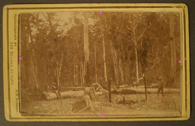
You then post again with your Burman photo No2 image
VPM208 Carte de Visite, A.W. Burman Stringybark Creek Re-enactment .Reproduced with permission from the collection of Victorian Police.
We appreciate your request and a fair question regarding a current photo of the ground, with four pink dots. I waited for the other team to reply first but it seems a long wait.
Here then in response is my special webpage that answers your question.
http://www.ironicon.com.au/twohutspano/twohutspano.html

_____________________________________________________________________

Joe, 24/07 You know I am not the one playing games. Previously on page 2 you have stated your position believing in the Kelly tree area, you recite only McIntyre's texts, but you make no reference to the Burman photos which should have helped you find a place for your mocked up tent. You placed it there purely due to distance from the creek ( 70 yards) but the area along SBC is the issue ! What PoorFlour is telling you is its not the site and requires no further explanation.

______________________________________________________________________


Hello Sheila, Good to see you making a contribution. Your question -

quote:


"I would like to know your views on the photograph that appeared in the Beautiful Mansfield Booklet in May 1897 titled Police Camp Wombat Ranges - Scene of Kelly Outrages. To me this photograph appears to have been taken not far south of the Kelly Tree with the background in a north-easterly direction."


I agree the picture it was taken along the area from the picnic ground to the Kelly tree, but there is insufficient information to be sure.
I have studied the topography maps and the hills in the background with a slight peak are those about 2KM away which would make it the hill near Dicks Landing and the Toombullup Sawmill. In my document page 24, I make the point the 1884 map and the 1885 allotment map which both show a hut, are in fact 160 metres apart.

This means two surveyors marked a hut to be the same hut. Remember this was 6 to 7 years after the event and only immediate associated people close to the event would know the true site location. All other people like the council willing to have settlers taking up this land were Not really in the Know, and as one surveyor had marked one map " Police Killed by the Kellys" and another " Scene of the Police Murders by the Kelly Gang" then it is fair to suggest these two separated sites somewhere near the 600 and 800 metre mark ( between the picnic ground and the Kelly tree), this area became enshrined as the place where it happened even though it had actually not.

How many locals of 1885 would have had a Burman photo of the police camp to compare the site. ( Yes a few would have ) Then 19 years later a group came along to revisit the sites non the wiser to be shown the area close to the picnic ground simply because an allotment map was marked with a hut site attributed to the police killed by the Kelly gang. From the map information this hut site is 644 metres from the creek junction - being where the picnic ground is today. This is why I believe the Beautiful Mansfield picture was taken there rather that near the 800 metre mark.

The fact is the Burman photos do not match any of the areas where huts were marked on maps except where we know two huts once stood at around the 1000 metre mark from the Cks junction.

Mr Pseudo and any others, we all still wait in anticipation for your site document.


Joe.D
Advanced Member


Australia
729 Posts

Posted - 29/07/2010 :  20:53:49  Show Profile  Email Poster  Visit Joe.D's Homepage  Reply with Quote
Hi Bill,
 

quote:


You placed it there purely due to distance from the creek


NO I did not. There are many other clues to locating the right spot. Many of these things have been mentioned in other postings.

Poorflour pls refer to the rise as per McIntyres latest posting.....in other words the true rise is to the East and can be seen without difficulty with ease from the road.

If you look carefully at the Burman Photograph you should be able to see, lying on the rise some logs. These logs will give you a true perspective of the rise. Focus off centre to the right of the Burman photo with the one post... disregard the photo with the two posts because it does not provide a clear view of the rise.

P.S.....The logs lay in a Horizontal position.

Joe.D
www.kellyhaunts.org
 

Go to Top of Page


Go to Top of Page
Sheila Hutchinson
Advanced Member


Australia
68 Posts

Posted - 31/07/2010 :  13:04:24  Show Profile  Email Poster  Visit Sheila Hutchinson's Homepage  Reply with Quote
Hi Bill and others,

Re the 1897 photograph taken at the Police Camp site

My opinion: If the group from Mansfield didn’t have first hand knowledge of where the police camp site was they would have taken a guide with them to show them the spot.

Remembering that by 1897 the area around SBC was inhabited by farming families some had been there for 12 years or so. I’m sure the residents of that time would have been made aware of where the tragedy took place.
In 1894 16 pupils were attending the Toombullup School in a building close to Mr Archers residence. (Archers’ farm was at the head of SBC)

Sheila
 
Go to Top of Page
kellycountry2000
Forum Admin


Australia
720 Posts

Posted - 31/07/2010 :  13:14:01  Show Profile  Email Poster  Reply with Quote
Re the 1897 photograph taken at the Police Camp site


Here is a 1:20,000 scale map with all the grids and some spot heights, the contours are ten mts.
The red line is from the about where the Kelly tree is to Dicks landing its about 2371 mts, you can see the tops of the hills, if you cannot figure out the tops of the hills I can colour them in, the tops of the hills are about 900-910 mts above sea level

Pic 1


This map is 1:15,000 gives a bit more detail

Go to Top of Page
robert mcgarrigle
Advanced Member


Australia
94 Posts

Posted - 31/07/2010 :  17:08:22  Show Profile  Email Poster  Reply with Quote
Joe I am looking at the number1 Burman photo with the one post and trying to find those horizontal logs (plural) that you speak of. I have blown up the copy of McMenomy's photo (page90) and blowed if I can see the horizontal logs. There is 1 small item to the right of the 2 white vertical trees at the right but I cannot say for sure that it is a log. Could you please enlighten me Joe ...Thanks Bob

Edited by - robert mcgarrigle on 31/07/2010 17:13:44


bill denheld
Advanced Member


Australia
118 Posts

Posted - 31/07/2010 :  19:53:56  Show Profile  Email Poster  Visit bill denheld's Homepage  Edit Reply  Reply with Quote  Delete Reply
Hello Joe, Previously 29/07 you are saying to PoorFlour -

quote:


If you look carefully at the Burman Photograph you should be able to see, lying on the rise some logs. These logs will give you a true perspective of the rise. Focus off centre to the right of the Burman photo with the one post... disregard the photo with the two posts because it does not provide a clear view of the rise. P.S.....The logs lay in a Horizontal position.


Joe, those logs to which you refer are just saplings no thicker than your arm if not your wrist. Very often you will see after a storm the tall lanky saplings down on the ground because they have no solid root structure.

______________________________________________________________________

Hello Bruce, thanks for that topographical map, The highest peak in the Mansfield image would have be the next hill north on your map images.
Here is a Google Earth view pointing to those hills that you measure to be 2.3 km away.


The yellow dots follow Ryans Creek along the Tolmie Tatong road to Stringybark Ck Road and south to the picnic ground white sqr dot. The two huts site roughly near the larger Sqr.

______________________________________________________________________

Hello Sheila, 31/07 Regarding your opinion, -

quote:


Remembering that by 1897 the area around SBC was inhabited by farming families some had been there for 12 years or so. I’m sure the residents of that time would have been made aware of where the tragedy took place.
In 1894 16 pupils were attending the Toombullup School in a building close to Mr Archers residence. (Archers’ farm was at the head of SBC)


As I previously discussed, with your new found allotment map of 1885 showing a hut at the 644 metre mark, that location became the spot.
We now also have the third Kelly tree, but no one can be sure where the first tree stood except to say it was close to where the Burman photo was taken. - That is the question ? -
Once a place becomes 'enshrined' by someone's mistake by plotting maps incorrectly, people then take that as gospel truth. I think you mentioned on this thread there was one family Healy and another ? who both had different knowledge of the correct site. Ian Jones accepted Healy's version for the east bank, yet the other thought it was on the west bank, and it is ironic that the two huts is diagonally opposite Healy's eastbank site. These two sites are side by side with a creek running through the middle.
The only SINGLE thing that can sort this out is the slope in the Burman photo. Find a north facing slope, the remains of two old huts, a bit of flat ground as in the photos, and as described as per the Mansfield reporter in the Herald, a large log south of a little hill from which you could overlook the police tent and you will have found the spot.
Bill

Here is a picture of the two huts site.
I am not suggesting this is where the the Mansfield image was taken, but there is no reason why it was not.

http://ironicon.com.au/twohuts/images/twohutsmansfieldscene.jpg


Sheila Hutchinson
Advanced Member


Australia
70 Posts

Posted - 01/08/2010 :  00:23:29  Show Profile  Email Poster  Visit Sheila Hutchinson's Homepage  Reply with Quote
Hi All,

The 1897 photograph etc

I believe the background view is of the area where the first McCashney & Harper sawmill site is located. I don’t believe the photograph would have been taken at or near the two huts site.

I wouldn’t say Ian Jones accepted Jack Healy's version
Admittedly Jack showed him this site but it was only after a good deal of research that Ian realised that the area he determined to be the site was the spot that Jack Healy had shown him some years earlier !!

The other chap believed the Police Camp site was just south of the present Kelly tree. His connection with the area dated back further than Jack Healy’s connection.

Sheila

 
Go to Top of Page
Thomas McIntyre
Senior Member


21 Posts

Posted - 01/08/2010 :  00:27:46  Show Profile  Email Poster  Reply with Quote
Well, Mr Denheld,
I continue with some more blah (having passed from your mortal world to this next world I have till eternity), as well as commenting on your “reasonable assumptions” made regarding the Beautiful Mansfield booklet’s photograph.
But before doing so I must say that Mrs Hutchinson in her latest reply does indeed take issue with your assumption (I now hesitate to use the describing term “reasonable”) that, and once again I quote “only immediate associated people close to the event would know the true site location. All other people like the council willing to have settlers taking up this land were Not really in the Know,”
Why Mr Denheld? First the booklet was issued by the Mansfield and District Progress Association and not the council! The place of our camp was close by to the bridle track –remember. This track was the route used by those passing through this valley on their way to gold diggings further north and indeed even through to the townships of the plains country and indeed those travelling south back to the Mansfield district. This track was an important thoroughfare and I would suggest that people, admittedly not all, using this track would by word of mouth, or by conversation with miners and indeed families as Mrs Hutchinson explains, be made cognizant of the position of the camp area.

Indeed in 1894, The Mansfield Courier commenced in the 10th February edition a report by the paper’s representative of a tour he made around all the properties in the Tolmie district. In the second installment of the report in the paper’s 17 February edition, the representative reported that “ Kelly gang: Jogging on the road again we came across a solitary miner, living in a hut on the exact spot where the police had their hut pitched at the time the Kelly gang committed the murders. He informed us, that he could only knock out a bare living.”
Now, indeed, Mr Denheld, where was this hut? Well I deem it to be the hut marked on the 1885 map to which you have previously made reference to.
I also must make comment on your statements that the “Creek is the Spring”.
Well Mr Denheld it is a pity that you haven’t taken the trouble to ensure this is so (you say this at page 23 of your report). What is true is that the Creek starts at its head point well to the South and on the other side of the old Tatong to Tolmie track on the rising ground because of the waters emanating from a spring, which is seasonal as it is subject to rainfall being sufficient over a period of time, just as the creek also is subject to this need of sufficient rainfall in the nearby surrounding country.
As for the creek being a spring, what bunkum that is.
But of course you need to have a spring near your two fireplaces as Ned has written in his Cameron statement:
“We approached the spring as close as we could get to the camp.”
AND the Argus of 28 October 1880 has these words (both about a spring and rising ground):
“Ned sent Dan over a little bit to where there was a spring and rising ground to watch for Kennedy & Scanlan”
and in describing when Sergeant Kennedy and Mounted Constable Scanlan returned to our camp site the newspaper says that:
“Dan was at the spring this time”.
My,my fancy sending your lookout to the lowest ground to be on watch!
Yes, there was a spring close by camp. It was very useful for the purpose of watering our horses (and another nearby spring can still be seen today, the one nearest our camp having now been extinguished because of the formation of a solid based road for those who must utilize the motor car. For many years this spring was the cause of much disruption to those who traversed the road with horse and buggy and motor car as it caused a significant area of ground to be boggy and even impassable at times. Oh, and both were and one still is on ground that can be described as rising).
Now to continue with some blah.
I again must remind you of my words
“When I had found the position of the tent I could have gone to the bodies blindfold. Starting from the tent I took a turn to the left between the stump and the log as shown in the accompanying engraving and then proceeding in the direction of the creek, outside the clearing where they had been searching. I showed them the body of Lonigan. All doubts about the truth of my story were removed by this confirmation of it. Then walking down the creek a little distance close to the bridle track I pointed to the body of Scanlon.”
As you choose to display for all to analyse your diagram of the alleged camp site I am of opinion that the diagram needs to show all pertinent indicators, and there is certainly none more pertinent than the positions you believe (or is that assume?) the bodies of my two fellow colleagues would be located.
Are you going to do so?
I conclude this by a further passage from the report of the special reporter of the Herald newspaper and of whose words I have previously quoted:
“Coming back to where Scanlan fell, I carefully examined the ground, and found a few gum leaves thoroughly saturated with his blood. Close to the pile of logs on which M’Intyre sat while the murderers waited the coming of Kennedy, and Scanlan, I found a number of the feathers of the parrot which M’Intyre shot in the morning before the Kellys came upon him. Taking some of these and the blood-stained gum leaves as souvenirs of my visit, and leaving Mr Burman to photograph the various scenes, I struck across country to pick up a police patrol which I understood was to pass, and to the officer in charge of which I had a letter. “
Now there is a challenge for all. Are these relics souvenired from the camp site to be found today? What a find it would be.

Oh, I almost forgot to say to you Mr Dipisa that it would seem your offer does not meet with the approbation of Poorflour (or is that Poorflours?). Perhaps if you also include an opportunity to attend a séance as Mr Fitzy has previously suggested you may receive a positive reply.

Thos.
 
Go to Top of Page
robert mcgarrigle
Advanced Member


Australia
97 Posts

Posted - 01/08/2010 :  10:35:41  Show Profile  Email Poster  Reply with Quote
Sheila in regard to the current so called shootout site, why won't the committee that made this decision make a public statement that they have got it wrong? The big selling Ian Jones dvd being sold everywhere in Victoria and other parts of Australia is still being sold giving people the idea that the site is on the east bank.Everyone here on this forum would just like to know the truth, that's why we are debating this subject .It now looks like according to Mr Standing that the slope is actually on the western slope, very interesting theory but I personally cannot see a sharp incline there. On my next trip I will have to get the camera out again and take some more shots. Ned Kelly now has introduced another polarising event "The Great SBC Debate",it looks like his story will live forever. No I do not think that Ned and his gang were heroes, our men and women in Afghanistan are.
Go to Top of Page
Joe.D
Advanced Member


Australia
731 Posts

Posted - 01/08/2010 :  13:55:40  Show Profile  Email Poster  Visit Joe.D's Homepage  Reply with Quote
Hi Robert,
Pls be patient as I'll make an attempt to upload the Burman pic, outlining the Logs/Saplings

Robert how did you enhance your Burman pic? the cleaner the pic the more detail is exposed

I enhance all my pic' by means of using officeworks printers.....i.e I have the burman pic saved on memory stick, officeworks down loads onto their HD and it is then printed via their larger printing machines. I recently had the B&W photo of Ned in chains (at the OMG) blown up to A1 .... the ring on his right finger can be seen quite easily however close up it looks somewhat distorted(pixalated).

Hiya Bill,

Thank you for correcting me Bill. However saplings....logs, makes no difference. I take it you agree there are saplings laying Horizontally on a rise....I'll have to make an assumption that some of the logs/saplings are thicker than that of my wrist.... but yes you are right some of them are no thicker than my wrist.

Bill, what is your point here....

Very often you will see after a storm the tall lanky saplings down on the ground because they have no solid root structure.

I have seen Trees of all shapes'n'sizes meet their fate after a storm.....and what has blown me away is smaller and more fragile (Saplings) trees live on to tell the tail.

Joe.D
Go to Top of Page
Joe.D
Advanced Member


Australia
731 Posts

Posted - 01/08/2010 :  14:39:29  Show Profile  Email Poster  Visit Joe.D's Homepage  Reply with Quote
Hi Robert,

Hope it works...x1 pic with referrence of Logs/Saplings on rise.

http://imgboot.com/image.php?u=kellyhaunts&i=burnamforkc2000.jpg

Joe.D
www.kellyhaunts.org
Stringybark Creek News and Views  
Go to -
Page1,  23,  4,  5,  6,  7,  8,  9,  10,  1112,  13,  14,  15,  16,  17, 18,  19,  20
               Previous Page | Next Page